How geospatial intelligence and Earth Observation data can make a big difference
Geospatial intelligence is often described as the knowledge one can acquire about the status and/or the activities on earth, derived from the analysis of geo-located imagery (satellite, airborne or other) and other geo–spatial information. This information describes and characterises objects, attributes and processes, which are tagged with a geographical location and a timestamp.
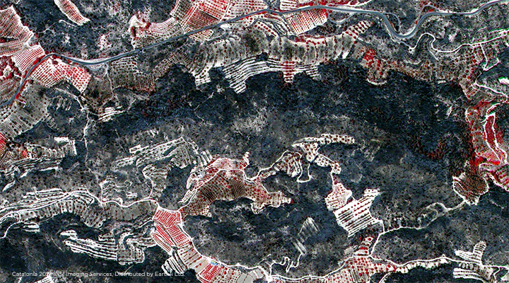
So how can this geospatial intelligence help in critical circumstances? These may arise after a natural disaster or emergencies caused by human activity, such as wildfires, earthquakes, landslides, cyclones or flood events, just to name a few. In particular, how can geospatial intelligence contribute to a best possible emergency response? A keyword often used in such circumstances is ‘Situational Awareness’, which is the perception of environmental elements and events with respect to time or space, the comprehension of their meaning, and the projection of their future status, for which geospatial intelligence is a key contributor.
What information is required for good situational awareness? Especially when looking at an emergency response (ER) situation, how can this information be derived and kept up to date? The first thing that comes to mind is having a good, very high-resolution map display with details about access or evacuation routes and other critical infrastructure. However, if this map is outdated, it may cause more confusion than help, so keeping it recent, and regularly updating the mapping based on Earth Observation (EO) data is essential.
For floods and wildfires, it is important to understand the topography of the area in question and having an up-to-date elevation model available will allow best possible modelling of the fire or flood spread. Land use classification and vegetation cover can also be derived from EO information, along with local weather observations and conditions which complement the assessment for any ER coordinators.
Other important ER geospatial information such as locations of hospitals, safe zones, and shelters for evacuations or simple things like petrol stations for fuel supply, need to be integrated into the best possible ER preparedness maps. This allows for optimal geospatial situational awareness. Such information then needs to be communicated regularly to all the stake holders, and their utilisation must be practised in ER training exercises. Preparedness applies hereby not only to governments on a national or regional level, but also to communities, big corporations or local enterprises. The higher the value of the assets or the bigger the respective threat – the more important preparedness becomes, including the up-to-date situational awareness.
Only by having such up-to-date base information can one assess the situation during and after an emergency event quickly, help affected people and communities, and avoid even more damages or loss of life. All of the incoming geospatial intelligence during and after the emergency in question needs to be put into context and related to the existing base and pre-event information.
Regular high and very high resolution EO data from optical and radar sources are essential for such a good level of ER preparedness and Earth-i is helping its customers to collate the required information, and compile, analyse and visualize all the geo-located and timestamped geospatial layers. Only a good level of preparedness will minimize the impacts of an emergency or disaster.
To find out more about Earth-i’s work surround disaster management, please email info@earthi.space.co.uk.